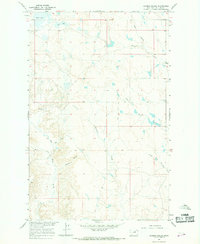
1965 Map of Barber Coulee
USGS Topo · Published 1969About this map
Second Creek Sch stands as a focal point of this rural Phillips County landscape, which was surveyed during the mid-1960s as part of the Missouri River Basin development program. The terrain is defined by an intricate network of drainage systems, including Barber Coulee and Fourchette Creek, which carve through the plains. The presence of isolated water sources like Shed Lake and Bean Lake in the northern section, along with various named springs and wells, highlights the essential role of water management for life in this part of Montana.
Find a feature on this map
13 named features on this map. Tap any name to fly to it.
Don’t see what you’re looking for? This feature index may not catch every label — zoom into the map to look around manually.
Map Details
Editions of this 1965 Barber Coulee Map
This is the sole edition of this map. No revisions or reprints were ever made.
Other maps of this area

1954 · Jordan
USGS Topo · 1:250,000

1954 · Lewistown
USGS Topo · 1:250,000

1956 · Jordan
USGS Topo · 1:250,000

1958 · Jordan
USGS Topo · 1:250,000

1959 · Lewistown
USGS Topo · 1:250,000

1964 · Jordan
USGS Topo · 1:250,000

1965 · Karsten Coulee
USGS Topo · 1:24,000

1965 · Veseth Reservoir
USGS Topo · 1:24,000

1965 · Dry Fork Ridge
USGS Topo · 1:24,000
1965 · Holzhey Reservoir
USGS Topo · 1:24,000