
1954 Map of Jordan
USGS Topo · Published 1965About this map
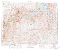
Jordan stands as the primary hub of this eastern Montana landscape, situated amidst a vast network of intermittent creeks and prairie ridges. Following the mid-century revisions to this survey, the influence of the Fort Peck Reservoir is prominent along the northern reaches, where the Charles M Russell National Wildlife Range spans the breaks. The sheer density of rural schoolhouses, such as Regina School, Tallow Creek School, and Haxby School, indicates a widely dispersed ranching population that relied on these localized centers for community and education.
Find a feature on this map
54 named features on this map. Tap any name to fly to it.
Don’t see what you’re looking for? This feature index may not catch every label — zoom into the map to look around manually.
Map Details
Editions of this 1954 Jordan Map
2 editions found
Other maps of this area

1914 · Nashua
USGS Topo · 1:62,500

1915 · Frazer
USGS Topo · 1:62,500

1915 · Oswego
USGS Topo · 1:62,500

1916 · Nashua
USGS Topo · 1:62,500

1943 · Glasgow
USGS Topo · 1:125,000

1953 · Miles City
USGS Topo · 1:250,000

1953 · Havre
USGS Topo · 1:250,000

1954 · Forsyth
USGS Topo · 1:250,000

1954 · Roundup
USGS Topo · 1:250,000

1954 · Glendive
USGS Topo · 1:250,000