1954 Map of Jordan
USGS Topo · Published 1978About this map
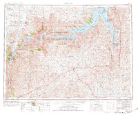
Fort Peck Lake dominates the northern landscape of this Garfield County survey, reflecting the transformation of the upper Missouri River following the construction of Fort Peck Dam. The map captures a vast expanse of central Montana during a period of agricultural stabilization, where small settlements like Jordan, Brusett, and Cohagen serve as vital hubs for the surrounding ranching country. The shoreline of the reservoir is intricately carved into numerous ridges and coulees, including Brown Ridge and Deadman Coulee, much of which is protected within the Charles M Russell National Wildlife Refuge. Away from the water, the terrain is defined by isolated landmarks such as Smoky Butte and the remote North Star School, illustrating the sparse but persistent settlement pattern of the high plains in the mid-20th century. This edition includes revisions from the 1970s, providing a look at the established infrastructure of highways 200 and 59.
Find a feature on this map
103 named features on this map. Tap any name to fly to it.
Don’t see what you’re looking for? This feature index may not catch every label — zoom into the map to look around manually.
Map Details
Editions of this 1954 Jordan Map
2 editions found
Other maps of this area

1914 · Nashua
USGS Topo · 1:62,500

1915 · Frazer
USGS Topo · 1:62,500

1915 · Oswego
USGS Topo · 1:62,500

1916 · Nashua
USGS Topo · 1:62,500

1943 · Glasgow
USGS Topo · 1:125,000

1953 · Miles City
USGS Topo · 1:250,000

1953 · Havre
USGS Topo · 1:250,000

1954 · Jordan
USGS Topo · 1:250,000

1954 · Forsyth
USGS Topo · 1:250,000

1954 · Roundup
USGS Topo · 1:250,000