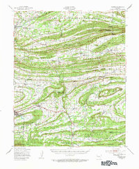
1947 Map of Barber
USGS Topo · Published 1954About this map
Backbone Mountain and Washburn Mountain dominate the topography of this Sebastian County landscape, where the ridges of the Ouachita Mountains dictate the patterns of settlement and travel. The northern reaches are consumed by the expansive Camp Chaffee Military Reservation, featuring specialized infrastructure like Target Track. Further south, the Chicago Rock Island and Pacific railroad cuts through the terrain, serving the established communities of Mansfield and Greenwood.
Find a feature on this map
80 named features on this map. Tap any name to fly to it.
Don’t see what you’re looking for? This feature index may not catch every label — zoom into the map to look around manually.
Map Details
Editions of this 1947 Barber Map
This is the sole edition of this map. No revisions or reprints were ever made.
Other maps of this area

1879 · Poteau Mountain
USGS Topo · 1:62,500

1879 · Fort Smith
USGS Topo · 1:62,500

1887 · Poteau Mountain #1
USGS Topo · 1:62,500

1887 · Van Buren
USGS Topo · 1:62,500

1887 · Mount Ida #2
USGS Topo · 1:62,500

1887 · Magazine Mountain #2
USGS Topo · 1:62,500

1887 · Magazine Mountain #3
USGS Topo · 1:62,500

1887 · Magazine Mountain
USGS Topo · 1:62,500

1887 · Poteau Mountain #2
USGS Topo · 1:62,500

1887 · Greenwood
USGS Topo · 1:62,500