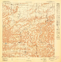
1947 Map of Barceloneta SO
USGS Topo · Published 1947About this map
Sabana Hoyos and the surrounding karst landscape are documented here in 1943 topograhy, just prior to the post-war industrial shifts in northern Puerto Rico. The area is defined by a dense network of small agricultural settlements and communal sites, including La Aldea, La Romana, and the Escuela Segunda Unidad de Sabana Hoyos. The Central Cambalache Railroad winds through the northern sectors, serving as a critical artery for the sugarcane economy that dominated the coastal plains and foothills of Florida Afuera and Florida Adentro. This survey illustrates the intricate land use patterns at the border of the Municipio de Arecibo and Municipio de Barceloneta, where the rugged limestone topography dictated the placement of roads and homesteads before modern highway expansion.
Find a feature on this map
17 named features on this map. Tap any name to fly to it.
Don’t see what you’re looking for? This feature index may not catch every label — zoom into the map to look around manually.
Map Details
Editions of this 1947 Barceloneta SO Map
This is the sole edition of this map. No revisions or reprints were ever made.
Other maps of this area

1942 · Arecibo
USGS Topo · 1:30,000

1942 · Barceloneta
USGS Topo · 1:30,000

1943 · Utuado NE
USGS Topo · 1:10,000

1946 · Barceloneta
USGS Topo · 1:30,000

1946 · Utuado
USGS Topo · 1:30,000

1946 · Arecibo
USGS Topo · 1:30,000

1946 · Florida
USGS Topo · 1:30,000
1947 · Barceloneta SE
USGS Topo · 1:10,000
1947 · Florida NO
USGS Topo · 1:10,000
1947 · Utuado NE
USGS Topo · 1:10,000
Featured Places
- Allende, Arecibo
- Asomante, Arecibo
- La Romana, Arecibo
- San Francisco, Barceloneta
- Reparto Arbelo, Barceloneta