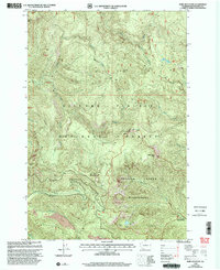
1998 Map of Bare Mountain
USGS Topo · Published 2003About this map
Government Mineral Springs serves as a notable landmark in the southeastern corner of this landscape, marking a site of long-standing interest near the southern edge of the Trapper Creek Wilderness. This 1998 revision of the earlier 1993 survey documents the high elevations of the Gifford Pinchot National Forest, where the terrain is defined by prominent summits including Bare Mountain, Observation Peak, and Siouxon Peak. The drainage patterns of the Cascades are clearly visible through the descent of Siouxon Creek and Chinook Creek, which carve through the dense forest toward lower elevations. Significant geological features such as the Lava fields and West Crater at the southern boundary underscore the volcanic history of the region. Localized points of interest like Soda Peaks Lake and the Paradise Hills provide specific reference points for those studying the land use and natural history of this portion of Skamania County.
Find a feature on this map
33 named features on this map. Tap any name to fly to it.
Don’t see what you’re looking for? This feature index may not catch every label — zoom into the map to look around manually.
Map Details
Editions of this 1998 Bare Mountain Map
This is the sole edition of this map. No revisions or reprints were ever made.
Other maps of this area

1919 · Mount St Helens
USGS Topo · 1:125,000

1926 · Steamboat Mtn
USGS Topo · 1:125,000

1926 · Hood River
USGS Topo · 1:125,000

1929 · Hood River
USGS Topo · 1:125,000

1931 · Steamboat Mtn
USGS Topo · 1:125,000

1940 · Lookout Mtn
USGS Topo · 1:62,500

1948 · Vancouver
USGS Topo · 1:250,000

1950 · Vancouver
USGS Topo · 1:250,000

1950 · Vancouver
USGS Topo · 1:250,000

1950 · Yakima
USGS Topo · 1:250,000