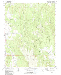
1994 Map of Barkelew Draw
USGS Topo · Published 1994About this map
Lilylands and Hamilton Mesa dominate this high-altitude landscape in San Miguel County, where ranching and resource extraction define the local economy. The map reveals an intricate network of irrigation canals, including the (South Lateral) and (North Lateral), which divert water across the mesa to support high-desert agriculture. Evidence of industrial activity is scattered throughout the terrain, marked by several Gas Wells and Drill Holes that signal the region's energy development in the late 20th century.
Find a feature on this map
23 named features on this map. Tap any name to fly to it.
Don’t see what you’re looking for? This feature index may not catch every label — zoom into the map to look around manually.
Map Details
Editions of this 1994 Barkelew Draw Map
This is the sole edition of this map. No revisions or reprints were ever made.
Other maps of this area

1916 · Paradox Valley
USGS Topo · 1:125,000

1922 · Paradox Valley
USGS Topo · 1:125,000

1956 · Cortez
USGS Topo · 1:250,000

1956 · Moab
USGS Topo · 1:250,000

1958 · Cortez
USGS Topo · 1:250,000

1959 · Cortez
USGS Topo · 1:250,000

1959 · Moab
USGS Topo · 1:250,000

1960 · Moab
USGS Topo · 1:250,000

1962 · Moab
USGS Topo · 1:250,000

1962 · Cortez
USGS Topo · 1:250,000