
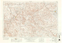
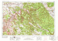
1956 Map of Moab
USGS Topo · Published 1972About this map
The confluence of the Colorado River and the Green River anchors this mid-century look at the High Plateau and canyon country of eastern Utah and western Colorado. Centered on the town of Moab, the landscape shows a complex network of deep drainages including Lockhart Canyon and Sevenmile Canyon, which define the approach to Canyonlands National Park. To the east, the dramatic rise of the La Sal Mountains is marked by peaks like Mount Peale and Mount Waas.
Find a feature on this map
173 named features on this map. Tap any name to fly to it.
Don’t see what you’re looking for? This feature index may not catch every label — zoom into the map to look around manually.
Map Details
Editions of this 1956 Moab Map
3 editions found
Other maps of this area

1885 · San Rafael
USGS Topo · 1:250,000

1885 · East Tavaputs
USGS Topo · 1:250,000

1885 · La Sal
USGS Topo · 1:250,000

1886 · Henry Mountains
USGS Topo · 1:250,000

1886 · Price River
USGS Topo · 1:250,000

1886 · Abajo
USGS Topo · 1:250,000

1892 · Abajo
USGS Topo · 1:250,000

1892 · Henry Mountains
USGS Topo · 1:250,000

1893 · Abajo
USGS Topo · 1:250,000

1896 · Price River
USGS Topo · 1:250,000