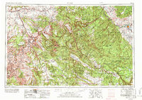
1956 Map of Moab
USGS Topo · Published 1972About this map
The Colorado River and Gunnison River carve through this high desert region, anchoring a landscape defined by deep canyons and expansive plateaus. The settlement of Moab serves as a central hub, surrounded by the dramatic geology of Arches National Monument and the northern reaches of Canyonlands National Park. The industrial and agricultural character of the era is evident in the cluster of towns along the San Miguel River, including the mining and milling centers of Uravan, Nucla, and Naturita.
Find a feature on this map
106 named features on this map. Tap any name to fly to it.
Don’t see what you’re looking for? This feature index may not catch every label — zoom into the map to look around manually.
Map Details
Editions of this 1956 Moab Map
3 editions found

Other maps of this area

1885 · San Rafael
USGS Topo · 1:250,000

1885 · East Tavaputs
USGS Topo · 1:250,000

1885 · La Sal
USGS Topo · 1:250,000

1886 · Henry Mountains
USGS Topo · 1:250,000

1886 · Price River
USGS Topo · 1:250,000

1886 · Abajo
USGS Topo · 1:250,000

1892 · Abajo
USGS Topo · 1:250,000

1892 · Henry Mountains
USGS Topo · 1:250,000

1893 · Abajo
USGS Topo · 1:250,000

1896 · Price River
USGS Topo · 1:250,000