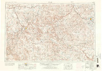
1956 Map of Moab
USGS Topo · Published 1972About this map
The Colorado River and its deep canyons anchor this mid-century survey of the Colorado Plateau, reflecting an era of expanding federal land management and resource extraction. The settlement at Moab serves as a central hub, situated near the dramatic geology of Arches National Monument and the early boundaries of Canyonlands National Park. This landscape is defined by its deep isolation and specific economic drivers, noted by the presence of a Uranium Mine and the route of the Denver and Rio Grande Western Railroad to the north near Thompson.
Find a feature on this map
121 named features on this map. Tap any name to fly to it.
Don’t see what you’re looking for? This feature index may not catch every label — zoom into the map to look around manually.
Map Details
Editions of this 1956 Moab Map
3 editions found

Other maps of this area

1885 · San Rafael
USGS Topo · 1:250,000

1885 · East Tavaputs
USGS Topo · 1:250,000

1885 · La Sal
USGS Topo · 1:250,000

1886 · Henry Mountains
USGS Topo · 1:250,000

1886 · Price River
USGS Topo · 1:250,000

1886 · Abajo
USGS Topo · 1:250,000

1892 · Abajo
USGS Topo · 1:250,000

1892 · Henry Mountains
USGS Topo · 1:250,000

1893 · Abajo
USGS Topo · 1:250,000

1896 · Price River
USGS Topo · 1:250,000