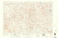
1960 Map of Moab
USGS Topo · Published 1960About this map
Moab serves as a central hub on the eastern edge of the Colorado River, anchoring a region defined by complex canyon systems and high mountain peaks. During the late 1950s, the landscape was deeply influenced by the extraction of uranium and vanadium, with specialized processing sites at Uravan and Naturita connected by the winding routes of the San Miguel River. To the north, the Denver & Rio Grande Western RR follows a more northern corridor through Cisco and Thompson, providing a critical rail link across the desert reaches of Grand County. The high-altitude terrain of the La Sal Mountains, featuring Mount Peale and Mount Tukuhnikivatz, stands in contrast to the deep depressions of Paradox Valley and Sinbad Ridge. Protected lands like Arches National Monument and the Manti-La Sal National Forest are already well-established, preserving the unique geological formations and watersheds that define this borderland between Utah and Colorado.
Find a feature on this map
147 named features on this map. Tap any name to fly to it.
Don’t see what you’re looking for? This feature index may not catch every label — zoom into the map to look around manually.
Map Details
Editions of this 1960 Moab Map
3 editions found

Other maps of this area

1885 · San Rafael
USGS Topo · 1:250,000

1885 · East Tavaputs
USGS Topo · 1:250,000

1885 · La Sal
USGS Topo · 1:250,000

1886 · Henry Mountains
USGS Topo · 1:250,000

1886 · Price River
USGS Topo · 1:250,000

1886 · Abajo
USGS Topo · 1:250,000

1892 · Abajo
USGS Topo · 1:250,000

1892 · Henry Mountains
USGS Topo · 1:250,000

1893 · Abajo
USGS Topo · 1:250,000

1896 · Price River
USGS Topo · 1:250,000