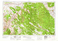
1960 Map of Moab
USGS Topo · Published 1960About this map
Moab serves as the focal point for this expansive regional study, situated at a critical crossing of the Colorado River during the mid-1950s. The landscape is defined by the high elevations of the Manti-La Sal National Forest, where peaks like Mount Peale and Mount Waas tower over the red rock formations of Arches National Monument. To the north, the Denver and Rio Grande Western RR traces the desert corridor through Thompson and Crescent Junction, while the eastern portion of the map covers the mining and milling settlements of western Colorado, including Uravan, Naturita, and Paradox. The map documents a rugged network of watercourses like Indian Creek and Hatch Wash, alongside geological landmarks such as Looking Glass Rock and Fisher Towers, capturing the era when uranium mining and ranching shaped the economic life of the plateau country.
Find a feature on this map
217 named features on this map. Tap any name to fly to it.
Don’t see what you’re looking for? This feature index may not catch every label — zoom into the map to look around manually.
Map Details
Editions of this 1960 Moab Map
3 editions found

Other maps of this area

1885 · San Rafael
USGS Topo · 1:250,000

1885 · East Tavaputs
USGS Topo · 1:250,000

1885 · La Sal
USGS Topo · 1:250,000

1886 · Henry Mountains
USGS Topo · 1:250,000

1886 · Price River
USGS Topo · 1:250,000

1886 · Abajo
USGS Topo · 1:250,000

1892 · Abajo
USGS Topo · 1:250,000

1892 · Henry Mountains
USGS Topo · 1:250,000

1893 · Abajo
USGS Topo · 1:250,000

1896 · Price River
USGS Topo · 1:250,000