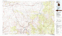
1983 Map of Moab
USGS Topo · Published 1987About this map
Moab serves as the focal point for this eastern Utah region during the early 1980s, where the winding Colorado River carves through a landscape defined by dramatic plateaus and deep canyons. The map documents the extensive reach of Arches National Park and the rugged Dome Plateau, illustrating how topography dictated the placement of settlements and transit. To the north, the Denver and Rio Grande Western railroad corridors connect outposts like Thompson and Crescent Junction.
Find a feature on this map
44 named features on this map. Tap any name to fly to it.
Don’t see what you’re looking for? This feature index may not catch every label — zoom into the map to look around manually.
Map Details
Editions of this 1983 Moab Map
3 editions found
Other maps of this area

1885 · San Rafael
USGS Topo · 1:250,000

1885 · East Tavaputs
USGS Topo · 1:250,000

1885 · La Sal
USGS Topo · 1:250,000

1886 · Price River
USGS Topo · 1:250,000

1896 · Price River
USGS Topo · 1:250,000

1916 · Paradox Valley
USGS Topo · 1:125,000

1922 · Paradox Valley
USGS Topo · 1:125,000

1948 · Roc Creek
USGS Topo · 1:24,000

1949 · Roc Creek
USGS Topo · 1:24,000

1949 · Juanita Arch
USGS Topo · 1:24,000