1975 Map of Barksdale
USGS Topo · Published 1975About this map
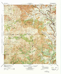
The Nueces River valley defines the character of this 1940s-era landscape, where the rugged topography of the Balcones Escarpment transitions into the Edwards Plateau. The settlement of Barksdale and the military outpost at Camp Wood serve as the primary hubs in a region dominated by family ranching operations. The map documents a high density of named ranch sites, such as the Embry Ranch, Rhodes Ranch, and Werner Ranch, illustrating the private landownership patterns of the mid-20th century. Prominent peaks including Pike Peak and Kelley Peak rise above the drainage systems of Pulliam Creek and Sycamore Creek. This survey, compiled from 1942 aerial photography, captures the network of water sources vital to the area's survival, from Dripping Springs to the Bull Water Hole, before modern infrastructure significantly altered the traditional ranching routes and rural precinct boundaries.
Find a feature on this map
114 named features on this map. Tap any name to fly to it.
Don’t see what you’re looking for? This feature index may not catch every label — zoom into the map to look around manually.
Map Details
Editions of this 1975 Barksdale Map
This is the sole edition of this map. No revisions or reprints were ever made.
