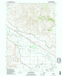
1990 Map of Barnes
USGS Topo · Published 1995About this map
The Grattan Massacre Historical Monument marks a pivotal 1854 conflict point within this Goshen County landscape, where the North Platte River corridor served as a critical artery for westward migration. The legacy of the westward expansion is etched across the terrain via the Emigrant Trail, which parallels the river valley and modern irrigation infrastructure. The map reveals an intricate hydraulic system essential to the high plains economy, including the Lucerne Canal, the Lucerne Siphon, and the Grattan Ditch. These waterways support the agricultural activity found at London Flats and near settlements like Barnes. North of the river, the topography transitions into a series of draws and canyons, such as Bovee Draw and Willy Draw, punctuated by landmarks like the Skinner Ranch and the Gross Reservoir.
Find a feature on this map
26 named features on this map. Tap any name to fly to it.
Don’t see what you’re looking for? This feature index may not catch every label — zoom into the map to look around manually.
Map Details
Editions of this 1990 Barnes Map
This is the sole edition of this map. No revisions or reprints were ever made.
Other maps of this area

1896 · Patrick
USGS Topo · 1:125,000

1896 · Hartville
USGS Topo · 1:125,000

1901 · Hartville
USGS Topo · 1:125,000

1950 · Rockeagle
USGS Topo · 1:24,000

1950 · Casebier Hill
USGS Topo · 1:24,000

1950 · Fort Laramie
USGS Topo · 1:24,000

1952 · Fort Laramie
USGS Topo · 1:24,000

1954 · Torrington
USGS Topo · 1:250,000

1958 · Torrington
USGS Topo · 1:250,000

1960 · Habig Spring
USGS Topo · 1:24,000