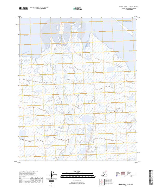
2024 Map of Barter Island A-4 SW
USGS Topo · Published 2024About this map
Arctic National Wildlife Refuge encompasses this entire stretch of the Alaskan North Slope, where the intricate hydrology of the coastal plain meets the Beaufort Sea. The landscape is dominated by the braided reaches of the Jago River, which flows northward through expansive wetlands before emptying into the protected waters of Jago Lagoon. This area represents a critical intersection of terrestrial and marine environments, featuring a complex network of thaw lakes and coastal features like Martin Point and the eastern reaches of Tapkaurak Lagoon. The map illustrates the specialized geography of the Arctic coast, where seasonal river discharge and sea ice dynamics constantly reshape the barrier islands and lagoon systems that define this remote wilderness.
Find a feature on this map
11 named features on this map. Tap any name to fly to it.
Don’t see what you’re looking for? This feature index may not catch every label — zoom into the map to look around manually.
Map Details
Editions of this 2024 Barter Island A-4 SW Map
This is the sole edition of this map. No revisions or reprints were ever made.
Other maps of this area

1951 · Barter Island
USGS Topo · 1:250,000

1951 · Demarcation Point
USGS Topo · 1:250,000

1955 · Demarcation Point
USGS Topo · 1:250,000

1955 · Barter Island A-5
USGS Topo · 1:63,360

1955 · Barter Island A-4
USGS Topo · 1:63,360

1955 · Demarcation Point D-5
USGS Topo · 1:63,360

1955 · Demarcation Point D-4
USGS Topo · 1:63,360

1959 · Barter Island
USGS Topo · 1:250,000

1964 · Demarcation Point
USGS Topo · 1:250,000
1964 · Barter Island
USGS Topo · 1:250,000