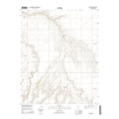
2014 Map of Bat Canyon
USGS Topo · Published 2014About this map
Moenkopi Plateau defines the southern extent of this landscape, its elevated surface dropping away into a complex system of drainage and erosion. The northern sections are dominated by the deep incision of Ha Ho No Geh Canyon, which winds across the northwest corner, and its namesake Bat Canyon, which cuts through the center of the sheet. These geological features illustrate the arid-land hydrology of the region, where water is a scarce and vital resource. The presence of Nez Spring suggests a rare perennial water source in an otherwise dry environment, likely serving as a critical point for local navigation or wildlife in the early 21st century. The map reflects a territory primarily defined by its physical geography rather than human infrastructure, as shown by the extensive public land survey boundaries.
Find a feature on this map
11 named features on this map. Tap any name to fly to it.
Don’t see what you’re looking for? This feature index may not catch every label — zoom into the map to look around manually.
Map Details
Editions of this 2014 Bat Canyon Map
This is the sole edition of this map. No revisions or reprints were ever made.
Other maps of this area

1883 · Marsh Pass
USGS Topo · 1:250,000

1883 · Tusayan
USGS Topo · 1:250,000

1886 · Tusayan
USGS Topo · 1:250,000

1886 · San Francisco Mtns
USGS Topo · 1:250,000

1886 · Echo Cliffs
USGS Topo · 1:250,000

1891 · San Francisco Mtns
USGS Topo · 1:250,000

1891 · Echo Cliffs
USGS Topo · 1:250,000

1892 · Marsh Pass
USGS Topo · 1:250,000

1894 · San Francisco Mtns
USGS Topo · 1:250,000

1899 · San Francisco Mtns
USGS Topo · 1:250,000