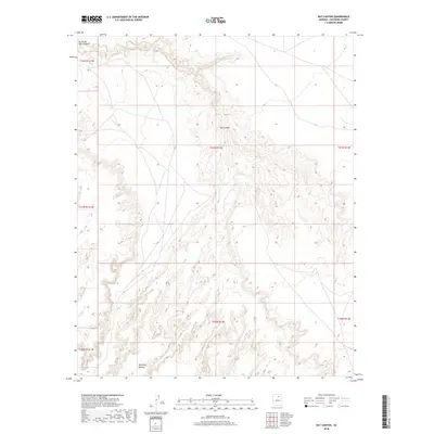
2018 Map of Bat Canyon
USGS Topo · Published 2018About this map
Bat Canyon and the surrounding high desert of Coconino County are defined by deep drainage networks and arid mesas in this late-career 2018 topographic survey. The landscape is dominated by the massive rise of the Moenkopi Plateau, which spans the southern portion of the sheet. Arroyos and intermittent watercourses characterize the hydrology here, with Nez Spring serving as a rare named water source amidst the complex terrain of the Painted Desert region. To the northwest, the map documents the carved margins of Ha Ho No Geh Canyon, showing the sharp relief typical of the Colorado Plateau's geological formations. This study is largely devoid of modern development, focusing instead on the natural landforms and the established Public Land Survey System township and range lines that grid this corner of Arizona.
Find a feature on this map
11 named features on this map. Tap any name to fly to it.
Don’t see what you’re looking for? This feature index may not catch every label — zoom into the map to look around manually.
Map Details
Editions of this 2018 Bat Canyon Map
This is the sole edition of this map. No revisions or reprints were ever made.
Other maps of this area

1883 · Marsh Pass
USGS Topo · 1:250,000

1883 · Tusayan
USGS Topo · 1:250,000

1886 · Tusayan
USGS Topo · 1:250,000

1886 · San Francisco Mtns
USGS Topo · 1:250,000

1886 · Echo Cliffs
USGS Topo · 1:250,000

1891 · San Francisco Mtns
USGS Topo · 1:250,000

1891 · Echo Cliffs
USGS Topo · 1:250,000

1892 · Marsh Pass
USGS Topo · 1:250,000

1894 · San Francisco Mtns
USGS Topo · 1:250,000

1899 · San Francisco Mtns
USGS Topo · 1:250,000