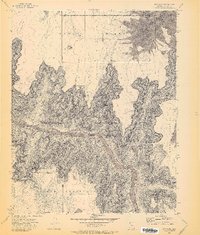
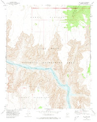
1971 Map of Bat Cave
USGS Topo · Published 1973About this map
The Hualapai Indian Reservation occupies the southern portion of this landscape, where the high desert terrain drops precipitously toward the Colorado River. This 1971 survey captures a period when the river was already altered by downstream management, forming the eastern reaches of Lake Mead within the Lake Mead National Recreational Area. The topography is dominated by the massive vertical relief of the Upper Grand Wash Cliffs and the wide, arid expanse of the Sanup Plateau. A small Landing Strip and the Bat Cave Towers provide rare evidence of human infrastructure in this remote corridor. Notable drainage features like Tincanebits Canyon carve through the plateau, while isolated water sources such as Granite Tank mark the challenging environment of the Arizona interior.
Find a feature on this map
13 named features on this map. Tap any name to fly to it.
Don’t see what you’re looking for? This feature index may not catch every label — zoom into the map to look around manually.
Map Details
Editions of this 1971 Bat Cave Map
2 editions found
Other maps of this area

1886 · Diamond Creek
USGS Topo · 1:250,000

1886 · Mt. Trumbull
USGS Topo · 1:250,000

1892 · Diamond Creek
USGS Topo · 1:250,000

1892 · Mt. Trumbull
USGS Topo · 1:250,000

1948 · Williams
USGS Topo · 1:250,000

1953 · Grand Canyon
USGS Topo · 1:250,000

1954 · Williams
USGS Topo · 1:250,000

1956 · Williams
USGS Topo · 1:250,000

1957 · Grand Canyon
USGS Topo · 1:250,000

1958 · Grand Canyon
USGS Topo · 1:250,000