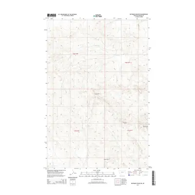
2014 Map of Bateman Coulee NE
USGS Topo · Published 2014About this map
Spring Coulee and Seven Tree Coulee cut through this Garfield County landscape, illustrating the intricate drainage patterns of the Missouri River breaks region. This 2014 survey documents the hydrography of the high plains, where ephemeral waterways like First Cr and Kelly Cr converge. The terrain is characterized by these deep coulees, including Sonny Coulee and Hobbs Coulee, which serve as vital landmarks for navigation and land management in this sparsely populated portion of eastern Montana. To the north, the E Fork Woody Cr and the main channel of Woody Cr define the flow of the local watershed. The map provides a clear record of the public land survey system divisions across townships t20n r40e and t20n r41e, highlighting how section lines interact with the natural topography of the coulees and creeks.
Find a feature on this map
13 named features on this map. Tap any name to fly to it.
Don’t see what you’re looking for? This feature index may not catch every label — zoom into the map to look around manually.
Map Details
Editions of this 2014 Bateman Coulee NE Map
This is the sole edition of this map. No revisions or reprints were ever made.
Other maps of this area

1954 · Jordan
USGS Topo · 1:250,000

1956 · Jordan
USGS Topo · 1:250,000

1958 · Jordan
USGS Topo · 1:250,000

1964 · Jordan
USGS Topo · 1:250,000

1964 · Ada Creek
USGS Topo · 1:24,000

1964 · Bateman Coulee
USGS Topo · 1:24,000

1964 · Black John Coulee
USGS Topo · 1:24,000

1964 · Bateman Coulee NE
USGS Topo · 1:24,000

1967 · Hagen Gap
USGS Topo · 1:24,000
1967 · Maxwell Coulee
USGS Topo · 1:24,000