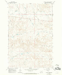
1967 Map of Maxwell Coulee
USGS Topo · Published 1970About this map
Big Dry Creek defines the northern hydrology of this Garfield County landscape, where a network of ephemeral drainage channels like Maxwell Coulee and Carcass Coulee carve through the high plains. The territory is marked by the infrastructure of ranching and resource extraction in the late 1960s, evidenced by numerous scattered Well sites and isolated Flowing Well labels that indicate the vital importance of groundwater in this arid region. The eastern portion of the map shows industrial activity at the Gravel Pits near the creek bed.
Find a feature on this map
16 named features on this map. Tap any name to fly to it.
Don’t see what you’re looking for? This feature index may not catch every label — zoom into the map to look around manually.
Map Details
Editions of this 1967 Maxwell Coulee Map
This is the sole edition of this map. No revisions or reprints were ever made.
Other maps of this area

1954 · Jordan
USGS Topo · 1:250,000

1956 · Jordan
USGS Topo · 1:250,000

1958 · Jordan
USGS Topo · 1:250,000

1964 · Jordan
USGS Topo · 1:250,000

1964 · Ada Creek
USGS Topo · 1:24,000

1964 · Bateman Coulee NE
USGS Topo · 1:24,000

1965 · Whiteside Ranch
USGS Topo · 1:24,000

1965 · Hafla School
USGS Topo · 1:24,000
1965 · Cohagen NE
USGS Topo · 1:24,000

1967 · Hagen Gap
USGS Topo · 1:24,000