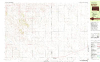
1981 Map of Batesland
USGS Topo · Published 1981About this map
Batesland sits at the southern edge of this West River landscape, captured in the early 1980s as a vital community point near the Shannon Co Bennett Co line. The map provides a detailed look at the interface between the Pine Ridge Indian Reservation Boundary and the surrounding plains. The drainage patterns of the High Plains are clearly defined here, with American Horse Creek and Porcupine Creek carving distinct paths through the terrain. To the north, the small settlement area of Wimer is noted alongside the winding Flesh Creek. The network of section lines and rural routes illustrates the distribution of homesteads and land use in this part of South Dakota, reflecting the ranching and agricultural character of the region just prior to the renaming of Shannon County.
Find a feature on this map
7 named features on this map. Tap any name to fly to it.
Don’t see what you’re looking for? This feature index may not catch every label — zoom into the map to look around manually.
Map Details
Editions of this 1981 Batesland Map
This is the sole edition of this map. No revisions or reprints were ever made.
Other maps of this area

1955 · Hot Springs
USGS Topo · 1:250,000

1955 · Martin
USGS Topo · 1:250,000

1958 · Martin
USGS Topo · 1:250,000

1967 · Wounded Knee
USGS Topo · 1:24,000

1967 · Denby
USGS Topo · 1:24,000
1981 · Wakpamani
USGS Topo · 1:25,000

1981 · Yellow Bear Camp
USGS Topo · 1:25,000

1981 · Allen
USGS Topo · 1:25,000

1981 · Evergreen
USGS Topo · 1:25,000

1981 · Ecoffey Lake
USGS Topo · 1:25,000