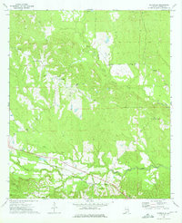
1973 Map of Batesville
USGS Topo · Published 1975About this map
Batesville serves as a small rural hub in southeast Alabama during the early 1970s, situated at the confluence of several local routes and the Central of Georgia rail line. The landscape is defined by the winding paths of the Middle Fork Cowikee Creek and South Fork Cowikee Creek, which drain the rolling terrain of Barbour County. This 1973 field-checked study illustrates a community anchored by its rural institutions, with several country churches like New Hope Ch and Humble Zion Ch scattered across the countryside.
Find a feature on this map
20 named features on this map. Tap any name to fly to it.
Don’t see what you’re looking for? This feature index may not catch every label — zoom into the map to look around manually.
Map Details
Editions of this 1973 Batesville Map
This is the sole edition of this map. No revisions or reprints were ever made.
Other maps of this area

1953 · Dothan
USGS Topo · 1:250,000

1954 · Dothan
USGS Topo · 1:250,000

1955 · Dothan
USGS Topo · 1:250,000

1955 · Phenix City
USGS Topo · 1:250,000

1957 · Phenix City
USGS Topo · 1:250,000
1957 · Pittsview
USGS Topo · 1:24,000

1958 · Phenix City
USGS Topo · 1:250,000

1968 · Eufaula North
USGS Topo · 1:24,000

1968 · White Oak
USGS Topo · 1:24,000

1968 · Clayton North
USGS Topo · 1:24,000