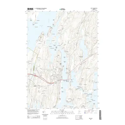
2014 Map of Bath
USGS Topo · Published 2014About this map
Bath serves as the focal point of this coastal survey, where the Kennebec River meets a complex network of channels and points. This 2014 mapping project details the dense grid of the city, from the waterfront of Front ST and Commercial ST to the historic cemeteries of Oak Grove Cem and First Parish Cem. The landscape is defined by its maritime connections, including the narrow navigation of The Chops Passage and the broad waters of Merrymeeting Bay. To the east, the settlement of Woolwich and the hamlet of Days Ferry sit across the river, connected by the Carlton Bridge and Wilder Bridge. The prevalence of small cemeteries and family-named landmarks like Butler Head and Trufant Ledge reflects centuries of continuous settlement in the Midcoast region. Farther inland, the terrain transitions toward Nequasset Lake and the agricultural lands near North Bath, showing how local roads like Old Stage RD have long integrated these riverfront communities.
Find a feature on this map
160 named features on this map. Tap any name to fly to it.
Don’t see what you’re looking for? This feature index may not catch every label — zoom into the map to look around manually.
Map Details
Editions of this 2014 Bath Map
This is the sole edition of this map. No revisions or reprints were ever made.
Other maps of this area

1892 · Gardiner
USGS Topo · 1:62,500

1893 · Wiscasset
USGS Topo · 1:62,500

1893 · Boothbay
USGS Topo · 1:62,500

1894 · Bath
USGS Topo · 1:62,500

1920 · Bath
USGS Topo · 1:62,500

1941 · Boothbay
USGS Topo · 1:62,500

1943 · Gardiner
USGS Topo · 1:62,500

1943 · Boothbay
USGS Topo · 1:62,500

1944 · Wiscasset
USGS Topo · 1:62,500

1944 · Boothbay
USGS Topo · 1:62,500