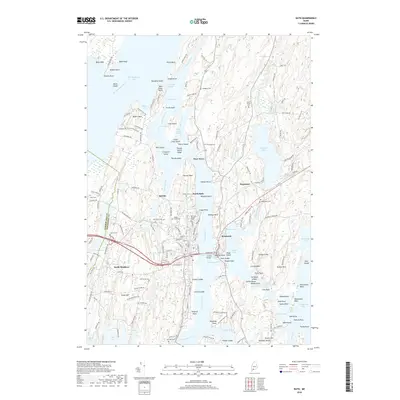
2018 Map of Bath
USGS Topo · Published 2018About this map
Bath occupies the center of this coastal Maine survey, situated where the Kennebec River narrows at The Chops Passage before reaching Merrymeeting Bay. The landscape is defined by its complex maritime geography, including the Androscoggin River confluence and the tidal reaches of Hockomock Bay. On the eastern bank, the town of Woolwich and the hamlet of Days Ferry overlook the river, while the Nequasset area is marked by its historic Pumping Station and Nequasset Lake. Genealogists will find a significant concentration of burial grounds throughout the area, from the large Oak Grove Cem and Maple Grove Cem in the city proper to smaller sites like Hodgkins Cem and Riverside Cem along the riverbanks. The map also traces the New Meadows River and numerous tidal creeks, documenting the proximity of inland settlements like North Meadows to the Atlantic coast.
Find a feature on this map
179 named features on this map. Tap any name to fly to it.
Don’t see what you’re looking for? This feature index may not catch every label — zoom into the map to look around manually.
Map Details
Editions of this 2018 Bath Map
This is the sole edition of this map. No revisions or reprints were ever made.
Other maps of this area

1892 · Gardiner
USGS Topo · 1:62,500

1893 · Wiscasset
USGS Topo · 1:62,500

1893 · Boothbay
USGS Topo · 1:62,500

1894 · Bath
USGS Topo · 1:62,500

1920 · Bath
USGS Topo · 1:62,500

1941 · Boothbay
USGS Topo · 1:62,500

1943 · Gardiner
USGS Topo · 1:62,500

1943 · Boothbay
USGS Topo · 1:62,500

1944 · Wiscasset
USGS Topo · 1:62,500

1944 · Boothbay
USGS Topo · 1:62,500