1920 Map of Bath
USGS Topo · Published 1920About this map
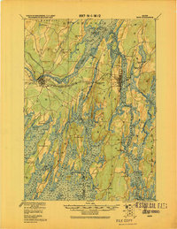
The Kennebec River and its intricate network of coastal inlets define this 1920 survey of coastal Maine. Significant transit infrastructure is visible, including the Maine Central R. R. and the Shore Line Electric R. R., which linked maritime communities like Bath and Brunswick. The map documents a period when water-based commerce and rail transport were deeply intertwined, evidenced by the numerous landings and stations such as Cathance Sta. and New Meadows Station. Inland, the landscape is marked by prominent elevations like Mount Ararat and Sprague Hill, while the coast is a labyrinth of sounds and bays including Harpswell Sound and Merrymeeting Bay. Small villages and hamlets, including Cundy Harbor and Parker Head, are shown with their building footprints, providing a detailed record of settlement patterns before modern coastal development transformed the region's character.
Find a feature on this map
145 named features on this map. Tap any name to fly to it.
Don’t see what you’re looking for? This feature index may not catch every label — zoom into the map to look around manually.
Map Details
Editions of this 1920 Bath Map
2 editions found

Other maps of this area

1892 · Gardiner
USGS Topo · 1:62,500

1892 · Freeport
USGS Topo · 1:62,500

1893 · Small Point
USGS Topo · 1:62,500

1893 · Casco Bay
USGS Topo · 1:62,500

1893 · Wiscasset
USGS Topo · 1:62,500

1893 · Boothbay
USGS Topo · 1:62,500

1894 · Bath
USGS Topo · 1:62,500

1908 · Lewiston
USGS Topo · 1:62,500

1914 · Casco Bay
USGS Topo · 1:48,000

1916 · Casco Bay
USGS Topo · 1:62,500