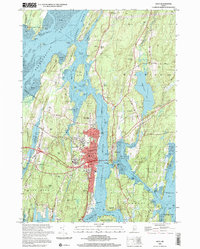
2000 Map of Bath
USGS Topo · Published 2001About this map
The maritime heritage of the Kennebec River is preserved here in the late twentieth century, centered on the industrial and civic heart of Bath. The city's shoreline is dominated by its shipbuilding legacy, featuring the Marine Mus, large Dry Dock facilities, and the historic Ferry Slips connecting to Woolwich. Across the river, the landscape of Towesic Neck and Arrowsic Island remains significantly less developed, defined by tidal flats and reaches like Fiddler Reach where the Doubling Point Light marks the channel.
Find a feature on this map
121 named features on this map. Tap any name to fly to it.
Don’t see what you’re looking for? This feature index may not catch every label — zoom into the map to look around manually.
Map Details
Editions of this 2000 Bath Map
This is the sole edition of this map. No revisions or reprints were ever made.
Other maps of this area

1892 · Gardiner
USGS Topo · 1:62,500

1893 · Wiscasset
USGS Topo · 1:62,500

1893 · Boothbay
USGS Topo · 1:62,500

1894 · Bath
USGS Topo · 1:62,500

1920 · Bath
USGS Topo · 1:62,500

1941 · Boothbay
USGS Topo · 1:62,500

1943 · Gardiner
USGS Topo · 1:62,500

1943 · Boothbay
USGS Topo · 1:62,500

1944 · Wiscasset
USGS Topo · 1:62,500

1944 · Boothbay
USGS Topo · 1:62,500