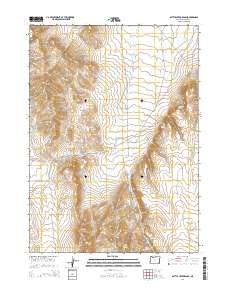
2014 Map of Battle Creek Ranch
USGS Topo · Published 2014About this map
Battle Creek Ranch anchors this high-desert landscape in southeastern Oregon, where a network of seasonal water sources and ranching access roads defines the local geography. The terrain is characterized by prominent elevations like the Bowden Hills and significant crossings such as Overshoe Pass. Vital water points, including Tree Spring, Cherry Spring, and Harper Spring, are scattered throughout the draws and canyons, supporting the livestock operations that have long shaped this part of Malheur County. The map details a complex system of drainage and relief, with Isaac Canyon and Barn Canyon cutting through the upland plateaus. This 2014 survey documents the persistence of remote ranching infrastructure, such as the Woolhawk Reservoir and the naming of access routes like Beber Ranch Rd and Potomac Ranch Rd, which follow the contours of the arid environment.
Find a feature on this map
24 named features on this map. Tap any name to fly to it.
Don’t see what you’re looking for? This feature index may not catch every label — zoom into the map to look around manually.
Map Details
Editions of this 2014 Battle Creek Ranch Map
This is the sole edition of this map. No revisions or reprints were ever made.
Other maps of this area

1955 · Jordan Valley
USGS Topo · 1:250,000

1957 · Jordan Valley
USGS Topo · 1:250,000

1958 · Jordan Valley
USGS Topo · 1:250,000

1979 · Bowden Ranch
USGS Topo · 1:24,000

1979 · Flat Top Mtn SE
USGS Topo · 1:24,000
1980 · Jackies Butte
USGS Topo · 1:24,000

1982 · Battle Mtn
USGS Topo · 1:24,000

1982 · Rattlesnake Canyon
USGS Topo · 1:24,000
1982 · Grasshopper Flat North
USGS Topo · 1:24,000
1982 · Basque
USGS Topo · 1:24,000