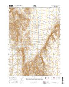
2017 Map of Battle Creek Ranch
USGS Topo · Published 2017About this map
Battle Creek Ranch sits at the heart of this high desert terrain in Malheur County, where the landscape is defined by drainage systems and ranch access roads. The topographic data reveals a complex network of canyons and passes, most notably Isaac Canyon, Barn Canyon, and the high crossing at Overshoe Pass. These natural features dictated the placement of historic routes like Rattlesnake Creek Rd and Potomac Ranch Rd, which follow the contours of the Bowden Hills.
Find a feature on this map
22 named features on this map. Tap any name to fly to it.
Don’t see what you’re looking for? This feature index may not catch every label — zoom into the map to look around manually.
Map Details
Editions of this 2017 Battle Creek Ranch Map
This is the sole edition of this map. No revisions or reprints were ever made.
Other maps of this area

1955 · Jordan Valley
USGS Topo · 1:250,000

1957 · Jordan Valley
USGS Topo · 1:250,000

1958 · Jordan Valley
USGS Topo · 1:250,000

1979 · Bowden Ranch
USGS Topo · 1:24,000

1979 · Flat Top Mtn SE
USGS Topo · 1:24,000
1980 · Jackies Butte
USGS Topo · 1:24,000

1982 · Battle Mtn
USGS Topo · 1:24,000

1982 · Rattlesnake Canyon
USGS Topo · 1:24,000
1982 · Grasshopper Flat North
USGS Topo · 1:24,000
1982 · Basque
USGS Topo · 1:24,000