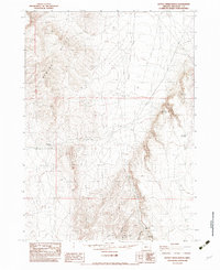
1982 Map of Battle Creek Ranch
USGS Topo · Published 1983About this map
Battle Creek Ranch serves as the focal point of human settlement in this high desert landscape of Malheur County. The terrain is defined by the steep rises of the Bowden Hills and the deep incisions of Isaac Canyon and Box Canyon. Water management is central to life in this arid environment, evidenced by scattered improvements such as Cherry Well, Woolhawk Reservoir, and numerous named water sources like Cherry Spring and Tree Spring. The map documents a network of unimproved roads and trails that traverse the complex topography, connecting remote points through high-elevation gaps like Overshoe Pass. These paths trace the natural contours of the land, winding through Barn Canyon and following the course of Battle Creek, illustrating the logistical challenges of ranching and movement in this part of southeastern Oregon during the late twentieth century.
Find a feature on this map
16 named features on this map. Tap any name to fly to it.
Don’t see what you’re looking for? This feature index may not catch every label — zoom into the map to look around manually.
Map Details
Editions of this 1982 Battle Creek Ranch Map
This is the sole edition of this map. No revisions or reprints were ever made.
Other maps of this area

1955 · Jordan Valley
USGS Topo · 1:250,000

1957 · Jordan Valley
USGS Topo · 1:250,000

1958 · Jordan Valley
USGS Topo · 1:250,000

1979 · Bowden Ranch
USGS Topo · 1:24,000

1979 · Flat Top Mtn SE
USGS Topo · 1:24,000
1980 · Jackies Butte
USGS Topo · 1:24,000

1982 · Battle Mtn
USGS Topo · 1:24,000

1982 · Rattlesnake Canyon
USGS Topo · 1:24,000
1982 · Grasshopper Flat North
USGS Topo · 1:24,000
1982 · Basque
USGS Topo · 1:24,000