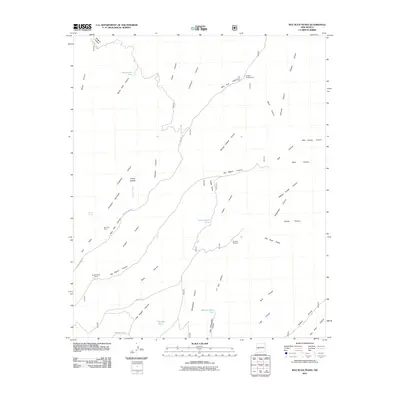
2011 Map of Bay Buck Peaks
USGS Topo · Published 2011About this map
Alexander Mountain and the Bay Buck Peaks anchor this landscape of deep canyons and water infrastructure in Socorro County. The map documents a network of seasonal water sources and ranching history, evidenced by Mouth of Bear Ranch and the Bear Trap Corral near Old State HWY 52. The land is defined by its drainage systems, where Fisher Canyon, Limestone Canyon, and Big Pigeon Canyon cut through the high terrain. Artificial water points like Baney Park Tank, Bitter Creek Tank, and the Scrapes Windmill reveal the essential modifications made to sustain livestock and travelers in this arid environment. Recreation and forestry management are also visible through Hughes Campground and the network of forest roads, including Forest RD 73, which provides access to the Turkey Saddle and surrounding draws.
Find a feature on this map
46 named features on this map. Tap any name to fly to it.
Don’t see what you’re looking for? This feature index may not catch every label — zoom into the map to look around manually.
Map Details
Editions of this 2011 Bay Buck Peaks Map
This is the sole edition of this map. No revisions or reprints were ever made.
Other maps of this area

1954 · Tularosa
USGS Topo · 1:250,000

1958 · Tularosa
USGS Topo · 1:250,000

1964 · Welty Hill
USGS Topo · 1:24,000

1964 · Bay Buck Peaks
USGS Topo · 1:24,000

1964 · Blue Mountain
USGS Topo · 1:24,000
1964 · Grassy Lookout
USGS Topo · 1:24,000

1964 · Monica Saddle
USGS Topo · 1:24,000

1965 · Oak Peak
USGS Topo · 1:24,000
1965 · Kellog Well
USGS Topo · 1:24,000

1965 · Dusty
USGS Topo · 1:24,000