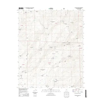
2013 Map of Bay Buck Peaks
USGS Topo · Published 2013About this map
Cibola National Forest encompasses this high-elevation terrain in Socorro County, where numerous canyons and draws carve through the landscape. The human presence here is defined by ranching and resource management, evidenced by features such as the Mouth of Bear Ranch and the Bear Trap Corral. Water management is central to life in this arid environment, with a series of named stock tanks like Baney Park Tank, Boulder Tank, and Pigeon Tank scattered across the township lines. High points including Alexander Mtn and the prominent Bay Buck Peaks overlook a network of drainage systems, including Hay Ground Draw and Foster Draw. Transportation is limited to rugged routes like Old State Hwy 52 and Forest Rd 73, serving both recreational users at the Hughes Campground and local agricultural interests marked by Scrapes Windmill.
Find a feature on this map
54 named features on this map. Tap any name to fly to it.
Don’t see what you’re looking for? This feature index may not catch every label — zoom into the map to look around manually.
Map Details
Editions of this 2013 Bay Buck Peaks Map
This is the sole edition of this map. No revisions or reprints were ever made.
Other maps of this area

1954 · Tularosa
USGS Topo · 1:250,000

1958 · Tularosa
USGS Topo · 1:250,000

1964 · Welty Hill
USGS Topo · 1:24,000

1964 · Bay Buck Peaks
USGS Topo · 1:24,000

1964 · Blue Mountain
USGS Topo · 1:24,000
1964 · Grassy Lookout
USGS Topo · 1:24,000

1964 · Monica Saddle
USGS Topo · 1:24,000

1965 · Oak Peak
USGS Topo · 1:24,000
1965 · Kellog Well
USGS Topo · 1:24,000

1965 · Dusty
USGS Topo · 1:24,000