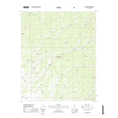
2020 Map of Bay Buck Peaks
USGS Topo · Published 2020About this map
Cibola National Forest encompasses the high-altitude terrain of Socorro County in this 2020 survey, where the Bay Buck Peaks rise as a central landmark. The landscape is defined by a dense network of drainages and canyons, including the long descent of Whitewater Canyon and Big Pigeon Canyon. Human presence is marked primarily by ranching and forestry infrastructure, such as the numerous livestock tanks like Baney Park Tank, Bitter Cr Tank, and Roberts Place Tank.
Find a feature on this map
53 named features on this map. Tap any name to fly to it.
Don’t see what you’re looking for? This feature index may not catch every label — zoom into the map to look around manually.
Map Details
Editions of this 2020 Bay Buck Peaks Map
This is the sole edition of this map. No revisions or reprints were ever made.
Other maps of this area

1954 · Tularosa
USGS Topo · 1:250,000

1958 · Tularosa
USGS Topo · 1:250,000

1964 · Welty Hill
USGS Topo · 1:24,000

1964 · Bay Buck Peaks
USGS Topo · 1:24,000

1964 · Blue Mountain
USGS Topo · 1:24,000
1964 · Grassy Lookout
USGS Topo · 1:24,000

1964 · Monica Saddle
USGS Topo · 1:24,000

1965 · Oak Peak
USGS Topo · 1:24,000
1965 · Kellog Well
USGS Topo · 1:24,000

1965 · Dusty
USGS Topo · 1:24,000