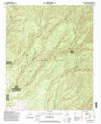
1995 Map of Bay Buck Peaks
USGS Topo · Published 1998About this map
Alexander Mountain and the Bay Buck Peaks anchor this section of the Cibola National Forest, where high-desert drainage systems create a complex network of canyons and draws. Surveyed in the mid-1990s, the landscape is defined by its water management for ranching, centered on the Mouth of Bear Ranch and various stock tanks like Roberts Place Tank and the Central Stock Tank Scrapes Windmill. The map tracks several major geographical transitions, including the First Standard Parallel South which cuts across the drainage basins of Whitewater Canyon and Bear Trap Canyon. This topography reveals how early land use was dictated by the seasonal flow of water through features such as Foster Draw and Indian Canyon, providing a look at Socorro County's ranching infrastructure before late-century modifications.
Find a feature on this map
40 named features on this map. Tap any name to fly to it.
Don’t see what you’re looking for? This feature index may not catch every label — zoom into the map to look around manually.
Map Details
Editions of this 1995 Bay Buck Peaks Map
This is the sole edition of this map. No revisions or reprints were ever made.
Other maps of this area

1954 · Tularosa
USGS Topo · 1:250,000

1958 · Tularosa
USGS Topo · 1:250,000

1964 · Welty Hill
USGS Topo · 1:24,000

1964 · Bay Buck Peaks
USGS Topo · 1:24,000

1964 · Blue Mountain
USGS Topo · 1:24,000
1964 · Grassy Lookout
USGS Topo · 1:24,000

1964 · Monica Saddle
USGS Topo · 1:24,000

1965 · Oak Peak
USGS Topo · 1:24,000
1965 · Kellog Well
USGS Topo · 1:24,000

1965 · Dusty
USGS Topo · 1:24,000