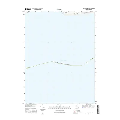
2016 Map of Bay Shore West OE S
USGS Topo · Published 2016About this map
Fire Island and its extension at Great South Beach dominate the northern fringe of this maritime survey, illustrating the narrow barrier beach system protecting the southern coast of Long Island. The map focuses primarily on the offshore waters of the Atlantic Ocean, with the terrestrial landscape limited to the shifting sands of Democrat Point and the coastal reach near Gilgo. Transportation onto the island is represented by the southern terminus of the Robert Moses State Pkwy, which provides access to the shoreline within Suffolk Co. This 2016 edition serves as a precise record of the barrier island's geomorphology, showing the relationship between the built infrastructure and the dynamic coastal environment before subsequent seasonal shifts.
Find a feature on this map
8 named features on this map. Tap any name to fly to it.
Don’t see what you’re looking for? This feature index may not catch every label — zoom into the map to look around manually.
Map Details
Editions of this 2016 Bay Shore West OE S Map
This is the sole edition of this map. No revisions or reprints were ever made.
Other maps of this area

1901 · Babylon
USGS Topo · 1:62,500

1902 · Fire Island
USGS Topo · 1:62,500

1903 · Babylon
USGS Topo · 1:62,500

1903 · Fire Island
USGS Topo · 1:62,500

1904 · Islip
USGS Topo · 1:125,000
1919 · Babylon
USGS Topo · 1:62,500
1941 · Bay Shore West
USGS Topo · 1:24,000

1942 · Islip
USGS Topo · 1:125,000

1944 · Bay Shore East
USGS Topo · 1:24,000
1947 · Jones Beach
USGS Topo · 1:24,000