
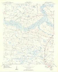
1949 Map of Bayboro
USGS Topo · Published 1949About this map
Lake Swamp and a complex network of wetlands dominate this 1940s landscape in Horry County, where the transition between dry ridges and low-lying bays shaped the local settlement patterns. Small communities and family homesteads are marked by a high density of rural schools and churches, including Athens Sch, Lewis School No 2, and Mt Pisgah Ch. The settlement of Bayboro serves as a southern anchor, while the surrounding terrain is defined by unique elliptical depressions like Horseskull Bay and High Hill Bay.
Find a feature on this map
57 named features on this map. Tap any name to fly to it.
Don’t see what you’re looking for? This feature index may not catch every label — zoom into the map to look around manually.
Map Details
Editions of this 1949 Bayboro Map
2 editions found
Other maps of this area

1937 · Nixonville
USGS Topo · 1:48,000

1942 · Nixonville
USGS Topo · 1:62,500

1943 · Adrian
USGS Topo · 1:24,000

1943 · Horry
USGS Topo · 1:24,000

1944 · Adrian
USGS Topo · 1:31,680

1948 · Galivants Ferry
USGS Topo · 1:24,000

1948 · Nichols
USGS Topo · 1:24,000

1948 · Bayboro
USGS Topo · 1:24,000

1949 · Duford
USGS Topo · 1:24,000

1949 · Georgetown
USGS Topo · 1:250,000