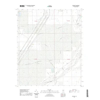
2020 Map of Bayland SE
USGS Topo · Published 2020About this map
The low-lying Yazoo Delta landscape around Limerick is defined by an intricate network of drainage channels and historic trails that crisscross the wetlands. The modern engineering of the Will M. Whittington Auxiliary Channel and the Yazoo River provide the primary hydrologic framework for the region, managed alongside extensive pipelines like the Texas Eastern Pipeline Trail. For genealogists, the map preserves the locations of several small family and community burial grounds, including the John Roberson Cem, Banks Cem, and Oak Valley Cem. A unique footprint of mid-century activity is visible in the Bombing Range Trail, suggesting a history of military training or testing in this corner of Yazoo County. The terrain is marked by numerous bayous and sloughs, such as Deep Bayou and Wade Bayou, which remain central features of this alluvial environment.
Find a feature on this map
35 named features on this map. Tap any name to fly to it.
Don’t see what you’re looking for? This feature index may not catch every label — zoom into the map to look around manually.
Map Details
Editions of this 2020 Bayland SE Map
This is the sole edition of this map. No revisions or reprints were ever made.
Other maps of this area

1940 · Mechanicsburg
USGS Topo · 1:62,500

1955 · Jackson
USGS Topo · 1:250,000

1961 · Jackson
USGS Topo · 1:250,000

1961 · Bayland
USGS Topo · 1:62,500

1961 · Valley
USGS Topo · 1:62,500

1962 · Jackson
USGS Topo · 1:250,000

1962 · Flora
USGS Topo · 1:62,500

1963 · Mechanicsburg
USGS Topo · 1:62,500

1984 · Yazoo City
USGS Topo · 1:100,000
1988 · Lucre
USGS Topo · 1:24,000