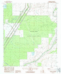
1988 Map of Bayland Se
USGS Topo · Published 1988About this map
The Panther Swamp National Wildlife Refuge dominates this Mississippi landscape, illustrating the intricate delta hydrology of the late 1980s. The terrain is defined by a dense network of waterways, including Tokeba Bayou, Wade Bayou, and Panther Bayou, alongside the engineering of the Will M Whittington Auxiliary Channel. Small settlements like Limerick and Wade sit near the margins of the refuge, while the Yazoo River winds through the southern portion of the sheet.
Find a feature on this map
18 named features on this map. Tap any name to fly to it.
Don’t see what you’re looking for? This feature index may not catch every label — zoom into the map to look around manually.
Map Details
Editions of this 1988 Bayland Se Map
This is the sole edition of this map. No revisions or reprints were ever made.
Other maps of this area

1940 · Mechanicsburg
USGS Topo · 1:62,500

1955 · Jackson
USGS Topo · 1:250,000

1961 · Jackson
USGS Topo · 1:250,000

1961 · Bayland
USGS Topo · 1:62,500

1961 · Valley
USGS Topo · 1:62,500

1962 · Jackson
USGS Topo · 1:250,000

1962 · Flora
USGS Topo · 1:62,500

1963 · Mechanicsburg
USGS Topo · 1:62,500

1984 · Yazoo City
USGS Topo · 1:100,000
1988 · Lucre
USGS Topo · 1:24,000