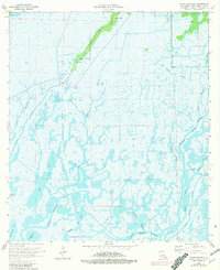
1964 Map of Bayou Sauveur
USGS Topo · Published 1964About this map
Bayou du Large and Grand Caillou Bayou dominate this coastal Louisiana landscape, defining the narrow strips of habitable land within the Terrebonne Parish wetlands. Life here is concentrated along the levees and ridges flanking these waterways, as seen in the cluster of religious sites like Immaculate Conception Ch, St Andrews Ch, and Bayou Du Large Ch that serve the local community. These waterways facilitate more than just transportation; they are integrated into an industrial network of energy extraction.
Find a feature on this map
21 named features on this map. Tap any name to fly to it.
Don’t see what you’re looking for? This feature index may not catch every label — zoom into the map to look around manually.
Map Details
Editions of this 1964 Bayou Sauveur Map
3 editions found
Other maps of this area

1894 · Bayou De Large
USGS Topo · 1:62,500

1894 · Dulac
USGS Topo · 1:62,500

1935 · Cocodrie
USGS Topo · 1:31,680

1935 · Theriot
USGS Topo · 1:31,680

1935 · Lake Mechant
USGS Topo · 1:31,680

1935 · Lake Quitman
USGS Topo · 1:31,680

1935 · Lake Gero
USGS Topo · 1:31,680

1935 · Lake Penchant
USGS Topo · 1:31,680

1940 · Bayou Du Large
USGS Topo · 1:62,500

1941 · Bayou Du Large
USGS Topo · 1:62,500