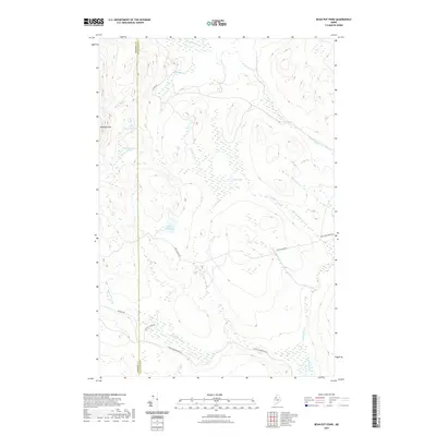
2021 Map of Bean Pot Pond
USGS Topo · Published 2021About this map
Mucalsea Mtn overlooks a remote landscape of northern Maine, where the border between Somerset Co and Piscataquis Co runs through a network of wetlands and logging roads. This 2021 survey shows a terrain dominated by hydrology, featuring Bean Pot Pond at its center and the extensive marshlands of Withey Bog. The hydrographic pattern is defined by Russell Stream and Loon Stream, which drain the various small ponds like Little Mucalsea Pond and Big Mucalsea Pond. Human presence is marked primarily by a specialized road network including Dead Man Brook Rd and Cassidy Deadwater Rd, alongside Boulett Camp Rd, which point to the area's ongoing use for timber and seasonal camps rather than permanent residential settlements.
Find a feature on this map
21 named features on this map. Tap any name to fly to it.
Don’t see what you’re looking for? This feature index may not catch every label — zoom into the map to look around manually.
Map Details
Editions of this 2021 Bean Pot Pond Map
This is the sole edition of this map. No revisions or reprints were ever made.
Other maps of this area

1954 · Seboomook Lake
USGS Topo · 1:62,500

1954 · North East Carry
USGS Topo · 1:62,500

1954 · Caucomgomoc Lake
USGS Topo · 1:62,500

1954 · St. John Pond
USGS Topo · 1:62,500

1954 · Presque Isle
USGS Topo · 1:250,000

1954 · Millinocket
USGS Topo · 1:250,000

1958 · Presque Isle
USGS Topo · 1:250,000

1958 · Millinocket
USGS Topo · 1:250,000

1958 · Caucomgomoc Lake
USGS Topo · 1:62,500

1958 · Saint John Pond
USGS Topo · 1:62,500