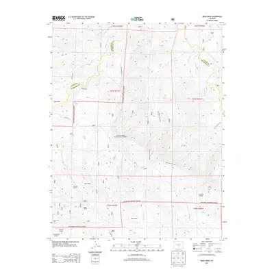
2013 Map of Bear Creek
USGS Topo · Published 2013About this map
San Isabel National Forest encompasses the vast majority of this high-altitude landscape, where the headwaters of the Saint Charles River and various forks of Bear Creek carve through the southern Colorado mountains. The terrain is defined by a series of deep drainage basins, including Reveille Canyon and Devils Hole, which illustrate the complex water management and natural topography of the Huerfano and Custer County border. The presence of Blue Spring and named geographic markers like Ute Log Gulch and Sand Hollow provides specific points of reference for local historians studying land use and water rights in this drainage network. Modern access remains limited to rugged tracks and trails such as Horse Ranch Trail 1397 and Pole Creek Trail 1398, which follow the contours of Pole Creek and the surrounding ridgelines, preserving the character of this remote forest interior.
Find a feature on this map
35 named features on this map. Tap any name to fly to it.
Don’t see what you’re looking for? This feature index may not catch every label — zoom into the map to look around manually.
Map Details
Editions of this 2013 Bear Creek Map
This is the sole edition of this map. No revisions or reprints were ever made.
Other maps of this area

1889 · Canon City
USGS Topo · 1:125,000

1889 · Huerfano Park
USGS Topo · 1:125,000

1892 · Huerfano Park
USGS Topo · 1:125,000

1892 · Canon City
USGS Topo · 1:125,000

1954 · Rosita
USGS Topo · 1:24,000

1954 · Trinidad
USGS Topo · 1:250,000

1954 · Pueblo
USGS Topo · 1:250,000

1955 · Trinidad
USGS Topo · 1:250,000

1957 · Pueblo
USGS Topo · 1:250,000

1958 · Trinidad
USGS Topo · 1:250,000