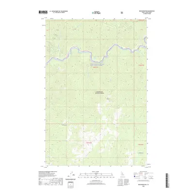
2020 Map of Bear Mountain
USGS Topo · Published 2020About this map
The Middle Fork Clearwater Wild and Scenic River and the Lochsa River dominate the northern landscape of this Idaho County territory. Within the protected bounds of the Clearwater National Forest, the terrain is defined by dramatic elevation changes between Bear Mtn and Freezeout Mtn. A significant concentration of geothermal activity is noted at Colgate Warm Springs, located just south of the main river corridor. The map reveals a network of drainage systems, including Postoffice Cr and Warm Springs Cr, which carve through the wilderness. To the south, the topography levels slightly at Wag Meadows near Wag Cr. This area remains largely undeveloped, with RD 564 serving as one of the few named access points into the high-country peaks and creek basins.
Find a feature on this map
27 named features on this map. Tap any name to fly to it.
Don’t see what you’re looking for? This feature index may not catch every label — zoom into the map to look around manually.
Map Details
Editions of this 2020 Bear Mountain Map
This is the sole edition of this map. No revisions or reprints were ever made.
Other maps of this area

1911 · Lolo
USGS Topo · 1:250,000

1913 · Lolo
USGS Topo · 1:250,000

1956 · Hamilton
USGS Topo · 1:250,000

1959 · Hamilton
USGS Topo · 1:250,000

1960 · Hamilton
USGS Topo · 1:250,000

1964 · Hamilton
USGS Topo · 1:250,000

1965 · Horseshoe Lake
USGS Topo · 1:24,000

1966 · Mc Connell Mtn
USGS Topo · 1:24,000
1966 · Hungry Rock
USGS Topo · 1:24,000
1966 · Bear Mountain
USGS Topo · 1:24,000