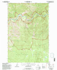
1994 Map of Bear Mountain
USGS Topo · Published 1997About this map
Lochsa River carves a deep valley through this corner of Idaho, serving as a central corridor within the Clearwater National Forest. The landscape is defined by its recreation-focused management, evidenced by the Colgate Licks Nature National Recreation Trail and the protected Recreational River Boundary. Natural thermal features like Colgate Warm Springs and the namesake landmark Jerry Johnson indicate long-standing points of interest for visitors and locals alike.
Find a feature on this map
24 named features on this map. Tap any name to fly to it.
Don’t see what you’re looking for? This feature index may not catch every label — zoom into the map to look around manually.
Map Details
Editions of this 1994 Bear Mountain Map
This is the sole edition of this map. No revisions or reprints were ever made.
Other maps of this area

1911 · Lolo
USGS Topo · 1:250,000

1913 · Lolo
USGS Topo · 1:250,000

1956 · Hamilton
USGS Topo · 1:250,000

1959 · Hamilton
USGS Topo · 1:250,000

1960 · Hamilton
USGS Topo · 1:250,000

1964 · Hamilton
USGS Topo · 1:250,000

1965 · Horseshoe Lake
USGS Topo · 1:24,000

1966 · Mc Connell Mtn
USGS Topo · 1:24,000
1966 · Hungry Rock
USGS Topo · 1:24,000
1966 · Bear Mountain
USGS Topo · 1:24,000