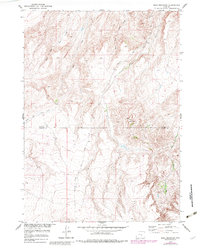
1951 Map of Bear Mountain
USGS Topo · Published 1983About this map
Bear Mountain dominates the landscape of this 1951 survey, situated along the border of Natrona County and Carbon County. The area is defined by a complex drainage system where Bear Creek and its West Fork meet, alongside the paths of Bolton Creek and North Fork Canyon Creek. While largely focused on the topography of the Missouri River Basin development, the map reveals human imprints such as the Bolton Road winding through the terrain. This edition includes revisions made in the early 1980s, providing a layered perspective of the high-altitude Wyoming backcountry as it transitioned through the mid-20th century.
Find a feature on this map
8 named features on this map. Tap any name to fly to it.
Don’t see what you’re looking for? This feature index may not catch every label — zoom into the map to look around manually.
Map Details
Editions of this 1951 Bear Mountain Map
3 editions found
Other maps of this area

1950 · Alcova SE
USGS Topo · 1:24,000

1950 · Alcova
USGS Topo · 1:24,000

1951 · Bear Mountain
USGS Topo · 1:24,000

1951 · Bear Spring
USGS Topo · 1:24,000

1953 · Fourmile Point
USGS Topo · 1:24,000

1953 · Fourmile Ridge
USGS Topo · 1:24,000

1955 · Casper
USGS Topo · 1:250,000

1958 · Casper
USGS Topo · 1:250,000

1960 · Twin Buttes
USGS Topo · 1:24,000

1960 · Wild Irish Reservoir
USGS Topo · 1:24,000