
Loading...
Loading map...1986 Map of Beaumont
USGS Topo · Published 1986About this map
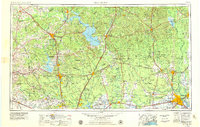
The Big Thicket National Preserve dominates this mid-1980s landscape, protecting the unique biological diversity of the East Texas piney woods. Between the Trinity River to the west and the Neches River to the east, the map reveals a region defined by its timber and energy heritage. Heavy infrastructure for the Oil and Gas Field industry is scattered across the prairies, particularly near Batson and Saratoga.
Find a feature on this map
118 named features on this map. Tap any name to fly to it.
Don’t see what you’re looking for? This feature index may not catch every label — zoom into the map to look around manually.
Map Details
Date Portrayed1986
Date Published1986
PublisherU.S. Geological Survey
Map TypeTopographic
Scale1:100,000
Physical Dimensions43.9 x 24.1 inches
Editions of this 1986 Beaumont Map
This is the sole edition of this map. No revisions or reprints were ever made.
Historical Maps of Beaumont Through Time
5 maps found


Featured Locations
Source Details
SourceU.S. Geological Survey
CopyrightPublic Domain