1932 Map of Beaumont
USGS Topo · Published 1932About this map
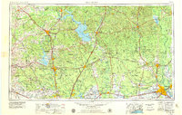
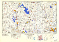
The Neches River snakes through this 1932 preliminary survey of the Texas coastal plains, defining the boundaries of Jefferson and Orange Counties. This edition represents a specific moment in time when aerial photography from the Air Corps was beginning to supplement ground surveys to document the complex drainage patterns of the region. The landscape is characterized by its intricate water systems, including the Beaumont Emergency Water Canal and tidal features like Maple Slough. Human settlement and infrastructure are clustered along the high ground and rail lines, with the Kansas City Southern and Pacific railroad serving as a vital corridor through Vidor. Local social life in the rural stretches is anchored by landmarks like Williamson Ch and the Pine Forest Sch, while Colliers Ferry provides a historical connection across the river before modern bridging dominated the region.
Find a feature on this map
23 named features on this map. Tap any name to fly to it.
Don’t see what you’re looking for? This feature index may not catch every label — zoom into the map to look around manually.
Map Details
Editions of this 1932 Beaumont Map
2 editions found
Historical Maps of Beaumont Through Time
5 maps found