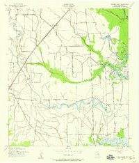
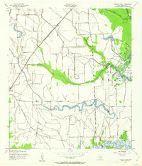
1943 Map of Fannett East
USGS Topo · Published 1959About this map
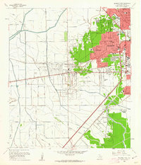
Jefferson County’s coastal prairies are defined here by a dense network of watercourses and the infrastructure of the early 1940s oil and cattle economy. The Gulf Colorado and Santa Fe railroad cuts diagonally across the landscape, linking the small settlements of Cheek and Fannett. This survey illustrates the vital role of water management in the region, with numerous pumping stations and canals integrated into natural features like Din Bayou and Pevitot Gully.
Find a feature on this map
24 named features on this map. Tap any name to fly to it.
Don’t see what you’re looking for? This feature index may not catch every label — zoom into the map to look around manually.
Map Details
Editions of this 1943 Fannett East Map
2 editions found
Other maps of this area
1926 · Vidor
USGS Topo · 1:24,000

1932 · Beaumont
USGS Topo · 1:62,500

1943 · Beaumont East
USGS Topo · 1:24,000

1945 · Fannett East
USGS Topo · 1:31,680

1950 · Houston
USGS Topo · 1:250,000

1954 · Beaumont
USGS Topo · 1:250,000
1955 · Sour Lake
USGS Topo · 1:62,500

1956 · Houston
USGS Topo · 1:250,000

1957 · Beaumont
USGS Topo · 1:250,000
1960 · Beaumont West
USGS Topo · 1:24,000