1950 Map of Houston
USGS Topo · Published 1953About this map
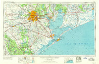
The Houston metropolitan area and the Gulf Coast during the early 1950s show a region defined by its connection to the sea and rapid industrial expansion. Central to this landscape is the nascent highway system, including the Gulf Freeway, and the massive flood control works of the Addicks Reservoir and Barker Reservoir to the west. The maritime economy is anchored by the Intracoastal Waterway and the Texas City Dike, reflecting a period when ports like Galveston, Baytown, and Texas City were vital hubs for petroleum and shipping.
Find a feature on this map
164 named features on this map. Tap any name to fly to it.
Don’t see what you’re looking for? This feature index may not catch every label — zoom into the map to look around manually.
Map Details
Editions of this 1950 Houston Map
This is the sole edition of this map. No revisions or reprints were ever made.
Historical Maps of Houston Through Time
4 maps found