
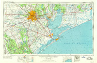
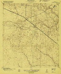
1956 Map of Houston
USGS Topo · Published 1963About this map
The expanding urban core of Houston serves as the focal point of this 1956 survey, showing a metropolis deeply connected to the Gulf coast through the industrial corridor of Pasadena, Deer Park, and Baytown. This era captures the height of the Texas oil boom, with the landscape dotted by legendary production sites like the Spindletop Oil Field and Humble Oil Field. To the south, the coastal economy is defined by the heavy infrastructure of the Port of Galveston and Port of Freeport, while the military presence at Ellington Air Force Base and Fort Crockett highlights the strategic importance of the shoreline during the mid-century.
Find a feature on this map
286 named features on this map. Tap any name to fly to it.
Don’t see what you’re looking for? This feature index may not catch every label — zoom into the map to look around manually.
Map Details
Editions of this 1956 Houston Map
2 editions found
Other maps of this area
1915 · Bellaire
USGS Topo · 1:24,000
1915 · Park Place
USGS Topo · 1:24,000

1915 · Houston Heights
USGS Topo · 1:24,000
1915 · Alief
USGS Topo · 1:24,000
1915 · Cypress
USGS Topo · 1:24,000

1915 · Deepwater
USGS Topo · 1:24,000

1915 · Katy
USGS Topo · 1:24,000
1915 · Addicks
USGS Topo · 1:24,000

1915 · Hillendahl
USGS Topo · 1:24,000

1915 · Clodine
USGS Topo · 1:24,000