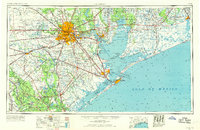
1956 Map of Houston
USGS Topo · Published 1969About this map
Houston serves as the sprawling urban center of this Upper Gulf Coast landscape, shown during a mid-century period of intense industrial and infrastructure expansion. The map details the complex maritime geography of Galveston Bay, Trinity Bay, and the Gulf of Mexico, illustrating how the region managed its vast water resources through projects like the Addicks Dam and Reservoir and the Barker Dam and Reservoir. Heavy industry and aerospace presence are evident in the development around Pasadena, Galena Park, and Ellington AFB, while the extensive rail network of the Southern Pacific and Santa Fe lines highlights the area's role as a primary transportation hub.
Find a feature on this map
118 named features on this map. Tap any name to fly to it.
Don’t see what you’re looking for? This feature index may not catch every label — zoom into the map to look around manually.
Map Details
Editions of this 1956 Houston Map
2 editions found

Other maps of this area

1915 · Bellaire
USGS Topo · 1:24,000

1915 · Park Place
USGS Topo · 1:24,000

1915 · Houston Heights
USGS Topo · 1:24,000

1915 · Alief
USGS Topo · 1:24,000

1915 · Cypress
USGS Topo · 1:24,000

1915 · Deepwater
USGS Topo · 1:24,000

1915 · Katy
USGS Topo · 1:24,000

1915 · Addicks
USGS Topo · 1:24,000

1915 · Hillendahl
USGS Topo · 1:24,000

1915 · Clodine
USGS Topo · 1:24,000